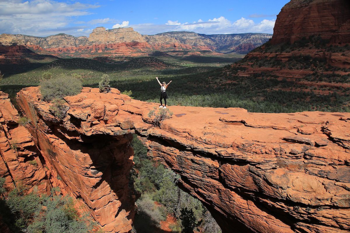
Waits can sometimes be long for the opportunity to pose atop Devil’s Bridge. (Mike Koopsen / Special for The Republic via Reuters Connect)
No one ever forgets the Sedona skyline. Towering formations, both fanciful and majestic, painted in fiery sunset hues rise above forested lands. It is an enticing landscape meant to be explored on foot. That’s where the 400 miles of available trails come into play.
While the hiking is second to none, the parking at trailheads can be challenging. To make things easier, the Sedona Shuttle runs Thursday through Sunday at popular trailheads. It’s a free ride and free parking. (For more details call 928-203-5152 or go to sedonashuttle.com.)
Many developed trailheads require a Red Rock Pass. The parking passes cost $5 daily or $15 weekly and are available at trailhead kiosks. Shuttle riders do not need to purchase a Red Rock Pass.
Fall and winter are perfect seasons for kicking up some red dirt. Here are 10 of the very best Sedona trails to get you started.
Sedona View Trail
Starting at the top of Airport Mesa, the path angles downhill through a thin screen of junipers revealing stunning panoramas below. You’ll parallel the road but be so wrapped up in vistas of Capitol Butte, Coffee Pot Rock and Chimney Rock, you won’t notice a few cars. The trail ends at a saddle where you can access Sedona Airport Loop if you want to continue hiking. The distinctive bald knob ahead is a popular vortex site. Enjoy a few meditative moments before making the half-mile climb back to your vehicle.
Where: Trail begins from the parking area atop Airport Mesa in West Sedona.
Cost: $3 parking at Airport Vista.
Length: 1.2 miles round-trip.
Bell Rock Pathway
This big, wide, rolling path makes this a great starter hike and it also connects to several other trails. Don’t expect solitude as Bell Rock Pathway is one of Sedona’s most popular outings. The trail brushes past the Bell Rock formation, then curves away from the road and crosses some red rock ledges offering impressive vistas. There’s also a strenuous route that scrambles to the top of Bell; a very different experience, so pay attention to the signage. Bell Rock Pathway ends at the Little Horse Trailhead.
Where: Trailhead is located on Arizona 179 just north of the Village of Oak Creek.
Cost: A Red Rock Pass is required for vehicles.
Length: 7 miles round-trip.
Courthouse Butte Loop
For a quieter adventure, start on Bell Rock Pathway, then peel off onto Courthouse Butte Loop about a half-mile from the parking lot. This scenic singletrack swoops through the juniper and pine fringe surrounding mighty Courthouse and leaves the crowds behind. Making a tight circle allows you to study Courthouse from all angles. On the backside watch for two distinctive formations, the spires of Rabbit Ears and the eerily smooth dome of Spaceship Rock. Rejoin Bell Rock Pathway and follow it back to the parking lot.
Where: Trailhead is located on Arizona 179 just north of the Village of Oak Creek.
Cost: A Red Rock Pass is required for vehicles.
Length: 4.5 miles round-trip.
Mescal Trail
After meandering through scrubby forest, this slender path climbs the flank of flat-topped Mescal Mountain, bristling with ocotillo. You’ll trace the edge of a stunning amphitheater along a stone shelf. Don’t panic when the trail splits with a sign indicating “difficult” and “extreme” options. That’s directed at mountain bikers. The trail drops off the toe of the mountain and junctions with Deadman’s Pass Trail at 2.2 miles. Return the way you came or create a loop by turning right on Deadman for 0.9 miles, a gentle ramble through manzanita to Long Canyon Trail. Another right on this smooth path returns to the trailhead.
Where: Parking is on Long Canyon Road 0.3 miles north of Dry Creek Road. Sedona Shuttle runs Thursday to Sunday.
Cost: A Red Rock Pass is required for vehicles.
Length: 4.8 miles round-trip.
Devil’s Bridge Trail
Expect plenty of company at Devil’s Bridge. Sedona’s largest sandstone arch offers a special photo opportunity so it has become a social media sensation. You can walk out onto the span and be photographed atop a magnificent arch framed by a lavish red rock backdrop. Instagram gold.
From the Mescal Trailhead, the trail rambles through brushy high-desert scrub. Near the end, it leads up a steep, rock stairway to an open area with great views. But don’t stop there. Keep going and the path climbs to the top of the arch, a high perch with breath-snatching panoramas. Wait times for photos can often be long.
Where: Mescal Trailhead is on Long Canyon Road 0.3 miles north of Dry Creek Road. Sedona Shuttle runs Thurs.-Sun.
Cost: A Red Rock Pass is required for vehicles.
Length: 4 miles round-trip.
Slim Shady-Made in the Shade Loop
From Yavapai Vista Trailhead, follow Kaibab Trail straight to Slim Shady, which parallels 179. The curvy singletrack ambles at a slight downhill through pines and junipers on the flank of rocky hills. Bell Rock and Courthouse Butte loom across the highway. Pass the first junction with Made in the Shade, but hang a right at the second to loop back. A gentle climb brings you closer to the cliffs for more outstanding views. You’ll also cross some slickrock ledges that make primo picnic spots.
Where: Yavapai Vista Trailhead is only accessible from the southbound lane of Arizona 179, 1.4 miles south of Back O’ Beyond.
Cost: A Red Rock Pass is required for vehicles.
Length: 3.2 miles round-trip.
Munds Wagon Trail
From the Schnebly Hill parking area, Munds Wagon Trail heads up Bear Wallow Canyon. It parallels rugged Schnebly Hill Road and views are devastating from the start. The trail stays level early on and crosses the road a couple of times before descending through a grove of Arizona cypress to a shallow drainage. Water flow is sporadic but you can usually find shallow pools. The trail junctions with Cow Pies Trail at 2 miles, a good turnaround point. The trail continues to climb and eventually twists up the Merry-Go-Round formation, where you’ll enjoy big panoramas back down the canyon.
Where: Trailhead is 0.8 miles up Schnebly Hill Road at the end of the pavement.
Cost: A Red Rock Pass is required for vehicles.
Length: 9 miles round-trip.
Little Horse Trail
If you like hikes ending with a big visual bonanza, take a stroll on Little Horse. Start out on wide Bell Rock Pathway before turning left at the signed fork and following an old jeep road across a dry streambed. You’ll climb through a stand of Arizona cypress guarding the flanks of a stony plateau marked by twin rock formations. After passing through a gate, the trail scrambles up the backside of Chicken Point, a broad open expanse of slickrock surrounded by abrupt colorful cliffs with views spilling across the valley.
Where: Trailhead is near milepost 310 on Arizona 179. Sedona Shuttle runs Thursday to Sunday.
Cost: A Red Rock Pass is required for vehicles.
Length: 3 miles round-trip.
Cathedral Rock Trail
This is another wildly popular trail, despite its steep, challenging nature, because it ends high amid the rock spires of an iconic formation. The path climbs to a stony basin where it intersects the Templeton Trail. From here Cathedral Rock Trail steepens dramatically, shinnying up rock faces, angling from ledge to ledge. A few strategic toeholds are notched in the rocks to help. Views are stunning as you snag a high saddle between the towering pinnacles.
Where: Trailhead is on Back O’ Beyond Road. Sedona Shuttle runs Thursday to Sunday.
Cost: A Red Rock Pass is required for vehicles.
Length: 1.1 miles round-trip.
Ground Control-Outer Limits Loop
Climb the shoulder of the Cockscomb using a moderate three trail loop. From the Aerie Trailhead start on Cockscomb Trail for a mile across open country. You’ll pass the junction with Outer Limits, which will be your return route. Turn right on Ground Control as it angles up the Cockscomb formation. Edgy and ledgy, the narrow passage hugs the cliff face above the valley floor. It feels a bit like a slow-motion carnival ride as you light-foot along dips and twists. The path curls beneath bristling columns and then drops steeply over the side. Outer Limits is waiting once you touch down so hang a right as it meanders through groves of ocotillos back to Cockscomb Trail. Turn left to complete the loop.
Where: Trailhead is on Boynton Pass Road.
Cost: Free.
Length: 3.5 miles round-trip.
For more information on Sedona trails, contact the Red Rock Ranger District. 8375 Arizona 179, 928-203-2900, fs.usda.gov/r03/coconino.
Reporting by Roger Naylor / Arizona Republic
MORE: A half day in Payson: Where to hike and eat

Your guide to the best Christmas lights in metro Phoenix
Christmas is nearly here. If you're looking for a festive activity the whole family is sure to love, you should plan an outing to enjoy Christmas...

10 Arizona events to check out this weekend (Dec. 19-21)
This events list was first published in The Copper Courier’s daily newsletter. Sign up here. Before we get into today's newsletter, I wanted to say...

Celebrate Hanukkah 2025 at one of these metro Phoenix events
Hanukkah, also known as the Festival of Lights, is an eight-night Jewish celebration that commemorates the rededication of the Second Temple in...

Ringing in the New Year 2026: Phoenix’s top spots to celebrate
Find the top New Year’s events in Phoenix, with options for party-goers, families, food lovers, and anyone ready to celebrate. The merry bells don’t...


