The monsoon is nearly upon us in Arizona, and most people are excited because it’s looking like a good chance to score some much-needed rainfall while getting some temporary reprieve from the otherwise scorching heat.
There’s no rain in the immediate forecast, but in preparation for the season, the National Weather Service has designated this “Monsoon Awareness Week” to inform people of the weather risks they may face. Threats include extreme heat, flash flooding, debris flows, lightning, downbursts and dust storms.
We’re going to discuss the positive forecast, but first, for any newcomers: The monsoon is a seasonal shift in wind patterns that results in a wet and dry season. Many only refer to it when we’re entering the wet season, which begins Monday, June 15, and lasts until Sept. 30 — the entire summer.
In the summertime, when the Earth is tilted toward the sun, we’re getting more direct heat and the polar jet stream shifts northward, so we get less of that cooler northern air.
MORE: 9 Arizona stereotypes that are actually pretty accurate
That makes room for an upper-level ridge, from the subtropical jet stream sitting to our south in Mexico, to also shift northward and expand into the Four Corners.
This is where the wind shift happens. High pressure rotates clockwise. So in the winter, we’re getting drier air straight from the west. As that high moves northward, winds instead come up from the south — and to our south are multiple bodies of water that saturate the air much more.
All of that happens higher in the atmosphere, but if we come back down closer to the surface, there’s a more daily land vs. sea interaction that also plays in. The two things you need to know here are that heat rises and as that happens, cold air is pulled into its place.
In the daytime, it gets extremely hot here on land. That actually draws in cooler air from those bodies of water — for example, the Gulf of California. It’s kind of like a sea breeze when you’re at the beach. The already hot air rises, hopefully making some clouds and storms on the way, and as it cools during its ascent, it moves out to sea. The cold air that took its place is now heating up to eventually follow the same path, and that cycle repeats.
Forecast points toward rain
Now onto the forecast, which again, looks positive. The Climate Prediction Center has cited above-normal rainfall across the state — a 30-40% chance for most, and nearly 50% in northeastern Arizona. It’s worth noting that the odds of above-normal precipitation are one of three categories: above, near or below normal. So the odds are not that much greater than having a normal monsoon — but it’s worth having your fingers crossed, especially considering the monsoon accounts for 30-60% of the annual precipitation. Remember that rainfall won’t be even across neighborhoods due to the scattered nature of these storms.
Another interesting factor is the record-low snowpack from last winter, which could bring about an earlier start to monsoon impacts — the ground is able to heat up sooner due to the lack of cover, allowing the upper-level high pressure to shift northward sooner.
And then, of course, there’s El Niño, one side of the El Niño-Southern Oscillation (ENSO) pattern. Weakening easterly winds over the Pacific Ocean allow warmer waters to pool in the east and center, and that often releases large amounts of heat into the atmosphere. Its impact on tropical precipitation patterns tends to have a domino effect on other global weather patterns.
Climate forecasts indicate this summer’s monsoon could bring above-normal rainfall, but this is not a direct result of El Niño. A recent analysis fromArizona National Weather Service offices showed that El Niño-influenced monsoons tend to have near- or above-normal rainfall, but there is no overwhelming correlation.
Forecasters compared years where El Niño was emerging, ongoing and ending, and what the rainfall totals were during each season. Overall, 38.5% of events were above normal, 42.3% were near normal and 19.2% were below normal.
Arizona’s opportunity to see more rainfall comes from El Niño’s impact on the Pacific hurricane season. Warmer-than-normal waters and weaker wind shear create ideal conditions for tropical cyclones to form.
While monsoon moisture doesn’t generally come from the Pacific Ocean, historical tracks show that a greater number of tropical cyclones push farther north toward Baja California in the later months of hurricane season. This increases the probability of that moisture entering the daily flow of the atmosphere and moving this way.
The increasing confidence in a super El Niño is based on the unprecedented impacts of climate change. Ocean temperatures are at record highs both at the surface and at depth, and the prospect of El Niño creating even more opportunity for warming is alarming to climate scientists.
El Niño is a phenomenon that strengthens over time, with the greatest intensity and impact occurring during winter. This is part of the reason forecast effects on the monsoon are less certain and less extreme — El Niño will still be developing beyond September, even if it is quite strong at that point, as forecast.
It’s important to note that a super El Niño does not equate to super-powerful impacts. It more so confirms the likelihood that impacts will occur. However, the intensification of extreme weather events has become a trend in recent years.
While on the topic of extreme weather impacts, it’s important to know all the risks you can face during the monsoon.
Extreme heat is necessary, but also a risk
Did you know there’s an ideal temperature range for thunderstorms to occur in Arizona? As daunting as it may be for 90% of the season to be over 100 degrees, it is a necessary evil for monsoon storm activity.
Temperatures between 100 and 108 degrees are ideal for convective development — convection being the rapidly rising air from which storms develop. If temperatures are too cool, there may not be enough energy for air masses to quickly rise and create instability. Too hot, and air mid-ascent could cap any air from rising above it, blocking any development; or if that strong cap is still broken, it could result in a dry thunderstorm, which still brings lightning and wind risks, without the benefit of any rainfall.
The Climate Prediction Center has forecast above-normal temperatures this season, which could raise the possibility of that latter scenario. Average summer temperatures already sit at the ideal range for convection.
Storm activity aside, hot temperatures and the seasonal humidity pose a great safety risk the longer you’re exposed to the elements. Extreme heat is the No. 1 weather-related cause of death in the U.S., so it should not be taken lightly, no matter how used to the heat you think you are.
The weather service uses the Heat Risk tool to supplement forecasts to show how impactful the heat is on a day-to-day basis. It’s scaled from 0-4 based on who could be affected, from no one at all, to sensitive groups like children and the elderly, to anyone who doesn’t receive heat relief after consistent exposure.
This is relevant overnight, as well, on days that temperatures don’t fall much. There were 23 days in summer 2025 when overnight lows were 90 degrees or greater.
The best advice includes staying hydrated, wearing light-colored clothing, sunglasses and hats, staying indoors during the hottest hours of 10 a.m.–6 p.m., and never leaving anything that breathes in a car unattended.
Follow this link to find the closest cooling center near you — the link includes centers across the state.
The dangers of flash flooding and debris flows
The most dangerous thing about flash floods is how quickly they can develop. In a desert climate, during a drought, especially in a city, can be a dangerous combination, so it’s important to have alerts enabled to stay informed about nearby flooding and other weather impacts.
Ground that has gone without water for a long time, as well as burn scars, can become hydrophobic, or water-repellent, making it easy for rainfall to exceed capacity. The risk is even greater on sloped surfaces, where a debris flow could trigger. A debris flow is a specific type of landslide saturated with water. The tricky part is that they can occur after a storm has ended and can travel miles beyond where it started.
The Arizona Emergency Information Network has a detailed page on debris flows — how to prepare, recognize and respond to them. Maricopa County also has a map of the local floodplain that highlights how vulnerable an area is to flooding.
If you’re not comfortable with maps, you can search for your address at the top. The closer you are to a riverbed or wash, the greater the chance of experiencing a flood event.
And as always: Turn around, don’t drown. Floodwaters can be deceptively deep or murky, and it’s impossible to know what may be beneath the surface. Flash floods claim an average of four lives each year in the area — let’s keep that number as low as possible.
Lightning is a signal to find shelter
Lightning is straightforward to discuss because the best advice is simple: Go inside.
Surely you’ve heard “When thunder roars, head indoors.” They’re a package deal — if you see lightning, thunder is on its way. Heat lightning does not exist; it’s simply lightning too far away to hear the accompanying thunder.
For a better estimate of how far away a storm is, start counting — every five seconds between a lightning strike and a thunder clap is equivalent to 1 mile. Keep in mind that cloud-to-ground lightning accounts for only 10% of all strikes, and Arizona sees more than 500,000 strikes during the monsoon. Exercise caution, especially at higher elevations.
Lightning poses the greatest environmental risk during the earlier weeks of the monsoon, when moisture may not yet be in place for significant rainfall, but dry thunderstorms can still develop. When lightning reaches the ground but rain cannot, the wildfire risk is significant — a single strike could be the spark in a drought-ridden landscape.
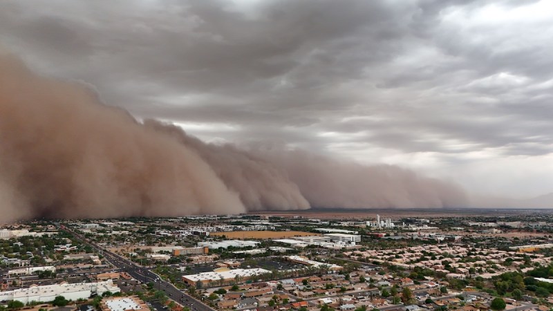
How downbursts and dust storms develop
Downbursts and dust storms often go hand in hand. Downbursts come from mature thunderstorms, when a column of cooled, fast-moving air is pushed downward and expands far beyond the thunderstorm cell. They are typically identified by the straight-line winds they produce. These winds can reach speeds comparable to tornadoes and can cause similar damage. They are somewhat random, making them difficult to forecast — much like the dust storms they can trigger.
Dust storms develop from the fast-sinking cool air of downbursts, which scoops up lightweight particles of dust, soil and silt from the hot ground. The cool air mass sinks and forces the warm air and dust at the surface to rise, and because of the instability already present in the atmosphere, dust can reach thousands of feet in the air and travel upward for 100 miles.
Dust storms are especially dangerous for motorists because visibility can quickly drop to zero. If you can’t see, pull over and wait it out.
The National Weather Service’s Monsoon Awareness Week runs from June 7 to June 13. You can find more resources and forecasts, and their social media pages on the agency’s Phoenix and Tucson websites.
Reporting by Tevian Whitehurst, Arizona Republic